


The National Weather Service says the Lower Peninsula should expect more high winds and the potential for tornados and hail Thursday afternoon.
“The mid-Michigan area would be included in the elevated threat area,” said Dan Cornish, a meteorologist with the National Weather Service in Gaylord. “All the way from the Lake Michigan shoreline over to Saginaw Bay.”
Temperatures are expected to get into the 80s across northern Michigan by Thursday afternoon, in addition to rising humidity levels, the National Weather Service says.
Harold Dippman, another meteorologist with the National Weather Service office in Gaylord, says that's going to create a lot of fuel for the thunderstorms and that all possible hazards are on the table.
Strong/severe thunderstorms are expected in Michigan late this afternoon into tonight. Severe storms are most likely in northern lower MI, especially south of M-32. Damaging winds are the primary threat. Large hail and a few tornadoes are also possible, along with heavy rain. pic.twitter.com/1ObH5V0nwA
— NWS Gaylord (@NWSGaylord) June 11, 2026
"With that system passing through [Wednesday] it also adds some changing direction of wind with height," Dippman said. "That does leave the potential for some pretty robust severe weather if everything can come together perfectly."
This comes after severe thunderstorms knocked tens of thousands of Michigan residents and businesses out of power Wednesday evening. According to poweroutages.us, a website that tracks outages across the country, around 59,000 utility customers were still in the dark as of Thursday morning.
Consumer's Energy says crews have restored power for over 50,000 customers after Wednesday's storms and they are prepared for Thursday's projected storm system with 500 crews on standby.
"Crews will be strategically staged as storms advance throughout the state," the company said in a statement.
Cornish says that this year is an “above average year,” for tornados. “On average, Michigan typically sees around 13 or 14 tornadoes, and we've surpassed that already,” he said.
An EF-1 tornado touched down in Freeland earlier this week, damaging between 30-40 homes Tuesday, according to the Saginaw County Emergency Management office.
Cornish says that hail is “more of a secondary threat,” compared to tonight's projected wind events.
In Alcona County, over 1,000 power outages are being reported, however 911 director Kathleen Realy says there was no major damage reports form last night after a tornado warning was issued.
“We're really not seeing much, actually, other than there are some power outages,” she said. “I believe they're localized in the southwest region of the county.”
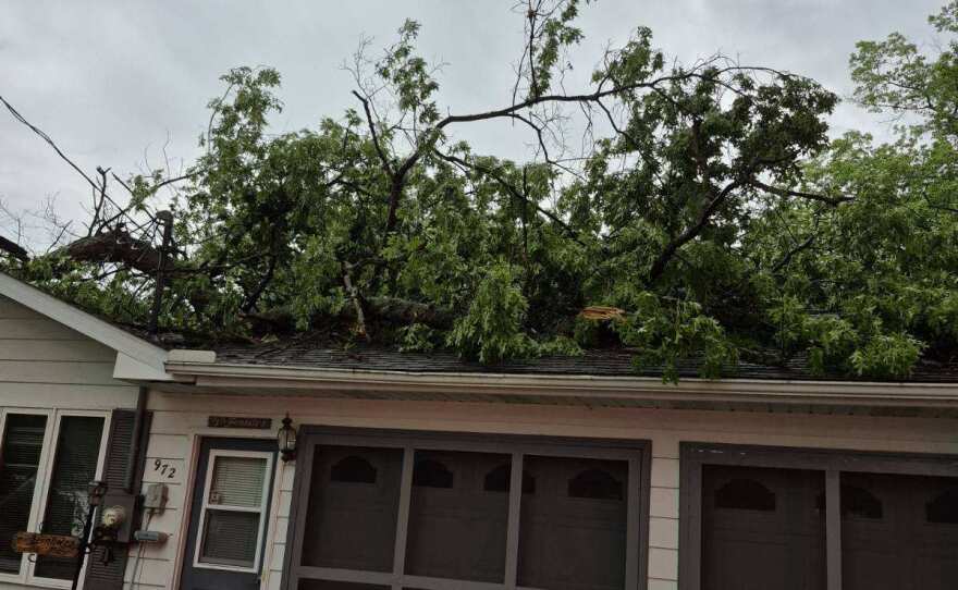
In Clare County, Emergency Management Director Jerry Becker told WCMU a house was severely damaged after a tree fell on it, caving the roof in last night.
In addition, he added that power crews were working and restored power to over 2,000 people there.
The Clare County Courthouse will be opened as a storm shelter, according to Becker.
"We can house hundreds in the basement," he said.
Realy and Corninsh recommend residents sign up for emergency alerts and stay informed on the weather. Realy says that the county has started sending emergency alerts through Everbridge.
“We are receiving some messages from citizens in the area affected last night [Wednesday] that did receive messages through the system,” she said.
Michiganders can find a list of resources on how to prepare for severe weather events through the MIReady website.


