-
 The remnants of wildfires in Canada and Minnesota drifted over the Great Lakes State on Wednesday. An air quality alert was issued by the National Weather Service for all of Michigan.
 -
 Heat exhaustion and heat stroke are two major signs of the impact of high temperatures, according to Emily Mueller of Munson Healthcare
 -
 This week, the National Weather Service says central and northern will see temperatures close to 100 degrees Fahrenheit.
 -
 Saginaw County Emergency Management reported 30-40 homes were damaged by the tornado, and over 2,200 people were without power as of Tuesday night.
 -
 Officials with the Michigan Department of Natural Resources have stationed five pumps near the dam to try and divert water as more rain and melting snow are projected in the forecast.
 -
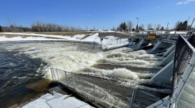 Water is now 18 inches from reaching the top, according to the Michigan State Police. If they reach 12 inches, the Michigan Department of Natural Resources says it will begin executing an emergency plan that will likely involved evacuations.
 -
 Nearly the entire Upper Peninsula is under an ice storm warning, with as much as half an inch of accumulation predicted in some areas, according to the National Weather Service.
 -
 The National Weather Service office in Gaylord told WCMU they don't expect the incoming system to be as severe as the ice storm and blizzard that struck the region a few weeks ago.
 -
 A key Doppler radar in Grand Rapids was down Monday afternoon as storms were expected overnight and severe weather chances increased Tuesday across parts of Michigan.
 -
 State and local officials across the Upper Peninsula are urging people to stay home and not travel unless necessary as a major winter storm continues to wreck havoc on the region, causing white-out conditions and heavy snow.

© 2026 Central Michigan University
Connecting Michigan... one story at a time.
Play Live Radio
Next Up:
0:00
0:00
Available On Air Stations


